.png)
 2 hours ago
1
2 hours ago
1
 Image source, Getty
BySimon King
Lead Weather Presenter
The Met Office has confirmed 2025 as the warmest and sunniest on record in the United Kingdom.
Provisional calculations show that with an average temperature of 10.09C, this exceeds the previous record of 10.03C set in 2022.
It means that 2025 joins 2022 and 2023 in the top 3 warmest years and it's only the second year where the mean annual temperature has exceeded 10C.
The last twelve months were also the sunniest on record with 1648.5 hours recorded, 61.4 hours more than the previous record set in 2003.
2025 will also be remembered for having one of the most notable windstorms - Storm Éowyn this century.
Here are the biggest weather moments of the year.
Hottest summer on record
Summer was notable for its four separate heatwaves and officially the hottest on record overall in the UK.
It started with an early June heatwave which brought maximum temperatures above 33C.
The mercury then climbed again later in the month with Wimbledon seeing its hottest start to the tournament on record.
A brief cooler spell in early July was followed by a third heatwave which brought Scotland, Northern Ireland and Wales their hottest weather of the year.
A fourth heatwave in August brought temperatures of 33.4C (92.1F) in parts of England, while 31.6C (88.9F) at Charterhall in the Borders, was Scotland's highest August temperature since 2003.
The warmth was often accompanied by blue skies with sunshine amounts above average across most of the UK.
With hosepipe bans in place there was a close eye on rainfall and drought going through the summer.
While overall across the UK, rainfall ended up being 84% of average, it was hugely variable with northern and western areas experiencing wetter than average weather with central, southern and eastern areas well below.
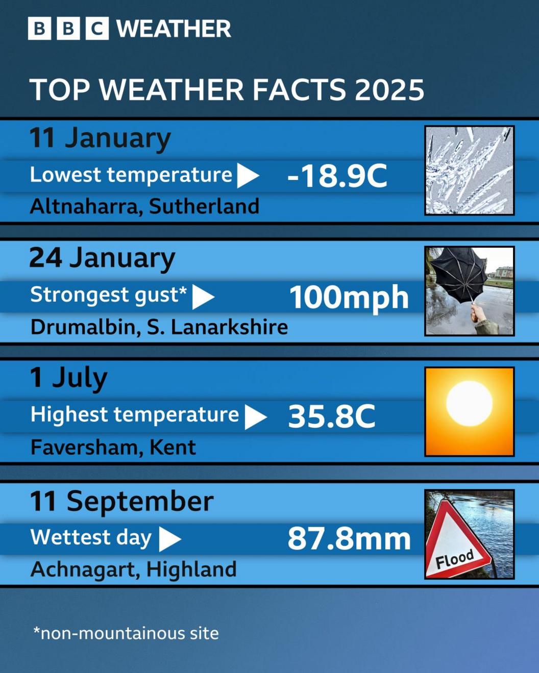
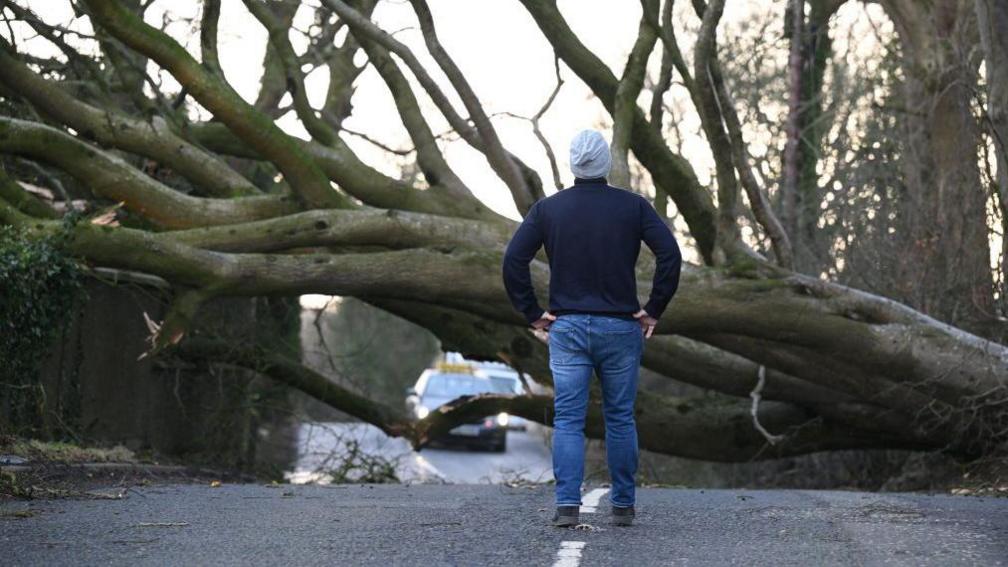 Image source, Getty
Storm Éowyn resulted in widespread damage after red weather warnings were issued
Red warnings for Storm Éowyn
Storm Éoywn hit the UK in late January with Northern Ireland and central Scotland experiencing the most severe conditions with wind gusts widely between 80 and 90mph.
The Met Office issued rare red warnings - the highest level of warning - for the Central Belt of Scotland and the whole of Northern Ireland with an amber warning across northern parts of the UK.
While there is no single measure for severity of storm in the UK, Storm Éoywn was notable as being the most powerful windstorm in a decade.
And in terms of most widespread wind gusts above 80mph, it ranked as the most notable in the 21st Century, according to the Met Office.
There was widespread transport disruption across Northern Ireland and Scotland with millions of people told to stay at home.
One man died when a tree fell on his car in County Donegal.
Storm Éoywn was the fifth named storm of the season and the biggest winter storm experienced in the UK until Storm Floris hit in early August.
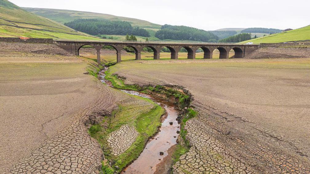 Image source, Getty
Reservoir levels across parts England fell to levels well below average after the one of the driest spring's on record
Drought
For much of spring - March, April and May - it was warmer than average.
All four UK nations recorded their warmest spring for mean temperature since it first began to be recorded in 1884, surpassing the previous record in 2024.
And overall across the UK, it was the warmest spring on record.
It was also notable for how dry the weather was, starting with the driest March since 1960 for England and Wales.
The dry, sunny and warm weather continued with April seeing the UK register a record number of hours of sunshine, and by mid-May the country was experiencing its driest spring in more than 100 years.
Spring was on track for being the driest on record - before thunderstorms and rain and the end of May brought the first measurable rain for some parts of the UK in weeks.
It ended up being the driest spring since 1974 - and the sixth driest on record for the UK as a whole - with the country receiving only just over half the expected rainfall.
Ahead of the summer there was some concern about the level of some our major reservoirs and talk about impending hosepipe bans with the National Drought Group at the time suggesting there was a 'medium risk' of official drought in the summer without sustained rainfall.
By July water restrictions and hosepipe bans were introduced for customers of Yorkshire Water, South East, Thames and Southern Water.
November extremes
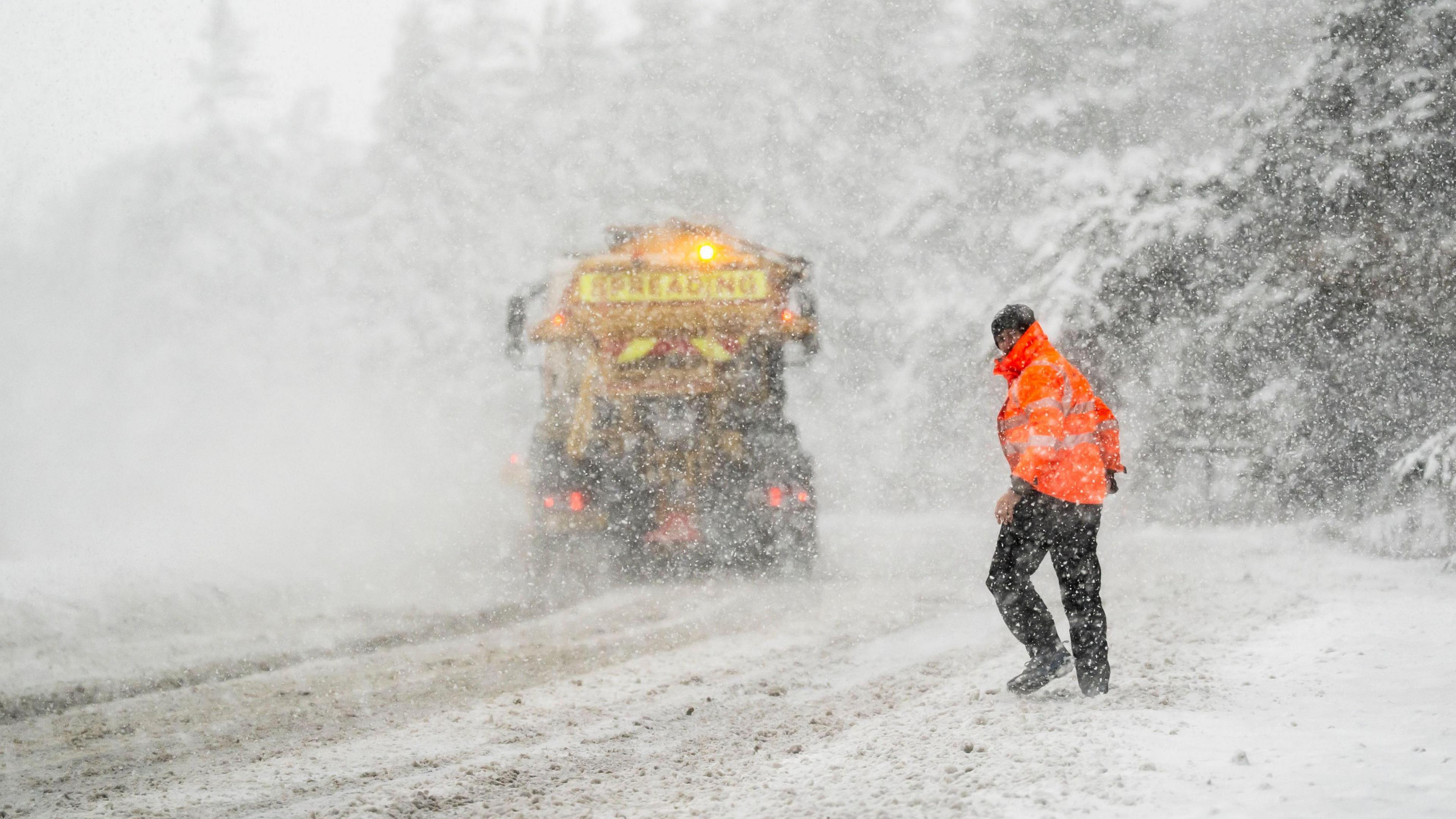 Image source, PA
Heavy snow fell in the North York Moors where there was an amber Met Office warning
In early November the weather was particularly mild with above average temperatures, especially overnight.
On Bonfire Night, traditionally a time to wrap up warm to watch fireworks, temperatures were higher than normal with a number of weather stations setting new November minimum temperature records for warmth.
And in Chivenor, Devon with a minimum temperature of 14.8C recorded on 5 November, it was the warmest Bonfire Night on record.
Soon after, an Arctic wind spread across the UK with temperatures falling quickly with significant snowfalls for some parts.
With -12.4 C recorded in Kinbrace, Highland on 11 November, it was the coldest November night in almost 15 years.
The cold northerly winds also resulted in frequent snow showers across northern and eastern Scotland and north east England where up to 25cm of accumulated snow gave some disruption.
A "Pembrokeshire Dangler" - a stream of showers, wintry in this case - also gave significant snowfalls in south west Wales and Cornwall.
Colder weather in autumn hasn't been that unusual in our past climate but in an increasingly warmer climate, snow and ice in early November is and will become more unusual.


 English (US) ·