.png)
 4 months ago
17
4 months ago
17
 Image source, Getty
Simon King
Lead Weather Presenter
Ben Rich
Lead Weather Presenter
With temperatures climbing over 30C (86F) in the coming days, the fourth heatwave of the summer is forecast.
Yellow heat health alerts, issued by the UK Health Security Agency, external have been issued for most of England, except the north-east and north-west region, from Monday to Wednesday.
Temperatures will exceed the official heatwave criteria for three consecutive days with a peak of 34C (93F) expected on Tuesday in the south Midlands.
It marks a big change in weather fortunes after Storm Floris battered parts of the UK earlier this week.
Heat building
Warm air will be drawn up from the south thanks to the interaction between high pressure drifting across the south of the UK and an area of low pressure - containing remnants of Tropical Storm Dexter - in the Atlantic.
England and Wales will have the best of the sunshine, although a few scattered thunderstorms are likely. Northern Ireland and Scotland can expect outbreaks of rain at times, especially on Monday.
After a warm weekend, temperatures really start to climb on Monday.
Temperatures across much of England and Wales will rise to the mid to high twenties, with some locations in the Home Counties and London exceeding 30C.
This will be the first day of the heat where the official heatwave criteria is met across many areas.
For an official heatwave to be defined, there needs to be three consecutive days with temperatures above 25 to 28C, dependant on where you are in the UK.
With very warm and humid air around until Wednesday, that will make it the fourth heatwave of the summer, particularly for east Wales, the Midlands, eastern and south-eastern areas of England.
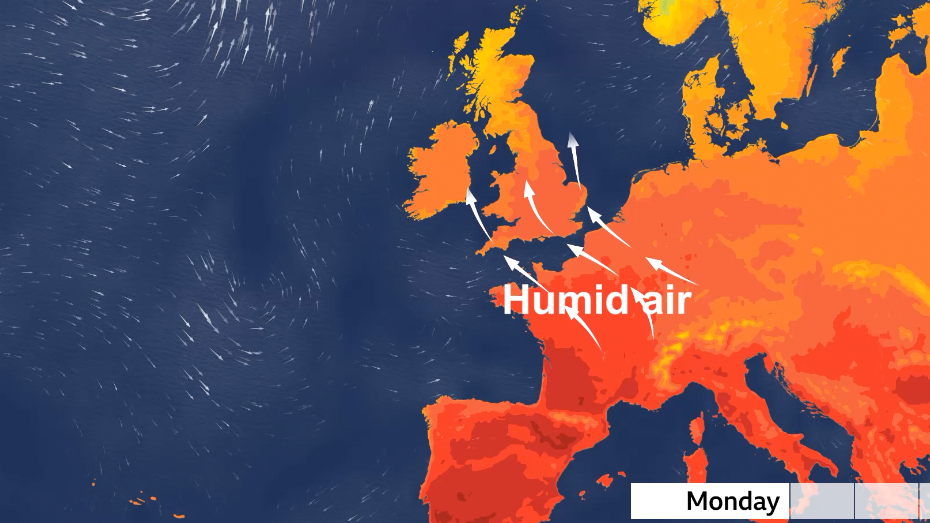
Very warm and humid air will be transported northward into the UK from Monday
How hot will it get?
The highest temperatures are likely on Tuesday with most of England and Wales getting maximum temperatures in the high-twenties.
It's across east Wales, the Midlands, East Anglia and south-east England where we'll widely exceed 30C, with potential for one or two locations around the south Midlands reaching 34C on Tuesday afternoon.
The only complication may be the development of some showers, which could turn heavy and thundery, moving northward across some parts of the UK.
There is still some uncertainty in that aspect of the forecast but you can always keep up to date with the very latest forecast for where you are on the BBC Weather app.
Pollen levels are also expected to rise to high across England during this hot spell.
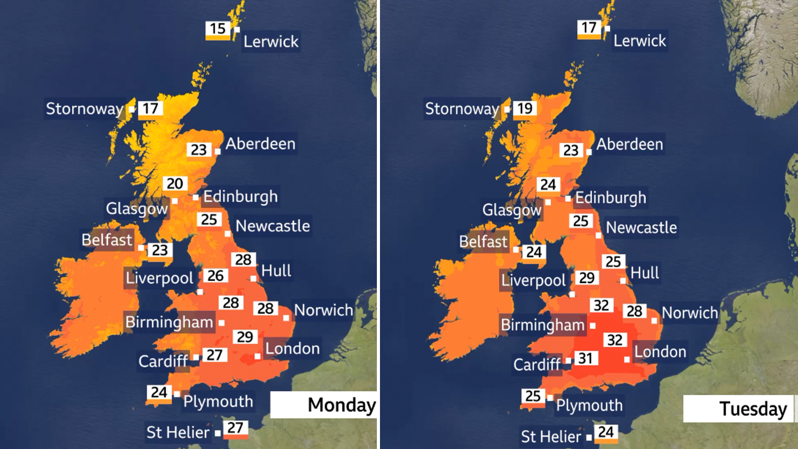
Temperatures will peak on Tuesday with highs widely exceeding 30C in the Midlands and south-east England.
Scotland and Northern Ireland look set to miss out on the hottest weather, with some rain at times - but could still see highs of 23-25C (73-77F) - which is still 4 to 7C above average.
What will the rest of August bring?
By the end of next week the winds from the south are due to be replaced by a flow of air from the Atlantic.
This would bring generally lower temperatures, although warmer than average weather is likely to hold on across southern and eastern parts of the UK at least.
Beyond that, the prospects look more mixed with some much-needed rain at times, but long-range forecasts suggest further spells of very warm or hot weather are likely during August, especially in the south and east.
You can always check the latest long-range forecast for the rest of the summer by taking a look at our monthly outlook.


 English (US) ·